 vesseltracker.com
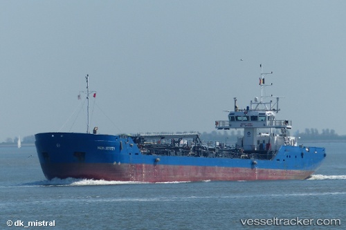
 NEW JERSEY
Current Status
Where is the vessel?
NEW JERSEY is currently in Near Zeebrugge, based on AIS data received about 14h ago.
Latest AIS update:
Current position: 51.34310° N, 3.19248° E (Near Zeebrugge)
Average speed (last 7 days): Loading…
Average speed (last 30 days): Loading…
Vessel profile: NEW JERSEY is a Oil Products Tanker with dimensions m x m.
This page combines live AIS, route history, probable destination signals, nearby traffic, and port activity for practical vessel monitoring.
The current position of vessel NEW JERSEY is 51.34310 lat / 3.19248 lng. Updated: 2026-05-17 23:24:08 UTCNearest reference points:
- Near Zeebrugge
- Near Thorntonbank
- Near Sas-Slijkens
Currently sailing under the flag of Netherlands ![]()
Details:
Live Vessel NEW JERSEY Analytics (details, animations, etc.)
Recent AIS points (UTC):
2026-05-17 20:09:09 UTC · 51.34303, 3.19252 · SOG 0.1 kn · COG 45°2026-05-17 21:43:18 UTC · 51.34306, 3.19250 · SOG 0 kn · COG 45°
2026-05-17 22:42:57 UTC · 51.34308, 3.19251 · SOG 0 kn · COG 46°
2026-05-17 23:24:08 UTC · 51.34310, 3.19248 · SOG 0.1 kn · COG 46°