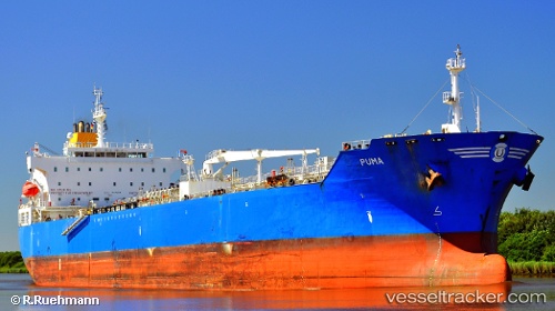
 PUMA
PUMA
Current Status
Where is the vessel?
PUMA is currently in Near QUINTERO, based on AIS data received about 14h ago.
Latest AIS update:
Current position: 32.74477° S, 71.51649° W (Near QUINTERO)
Average speed (last 7 days): Loading…
Average speed (last 30 days): Loading…
Vessel profile: PUMA is a Chemical/Oil Products Tanker with dimensions 32m x 183m.
This page combines live AIS, route history, probable destination signals, nearby traffic, and port activity for practical vessel monitoring.
The current position of vessel PUMA is -32.74477 lat / -71.51649 lng. Updated: 2026-05-19 22:04:45 UTCNearest reference points:
- Near Valparaiso
- 28 nm W of Pichilemu
- 100 nm W of Curauma
Currently sailing under the flag of Chile ![]()
PUMA built in 2009 year
Deadweight:
51215 tDetails:
Live Vessel PUMA Analytics (details, animations, etc.)
Recent AIS points (UTC):
2026-05-19 17:43:45 UTC · -32.74604, -71.51608 · SOG 0 kn · COG 275°2026-05-19 19:55:48 UTC · -32.74524, -71.51618 · SOG 0.1 kn · COG 243°
2026-05-19 20:25:47 UTC · -32.74502, -71.51629 · SOG 0 kn · COG 232°
2026-05-19 22:04:45 UTC · -32.74477, -71.51649 · SOG 0 kn · COG 221°