 vesseltracker.com
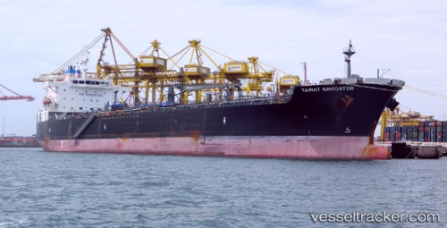
 Tamiat Navigator
Current Status
Where is the vessel?
Tamiat Navigator is currently in 19 nm W of Les Mechins, based on AIS data received about 14h ago.
Latest AIS update:
Current position: 49.07013° N, 67.42945° W (19 nm W of Les Mechins)
Average speed (last 7 days): Loading…
Average speed (last 30 days): Loading…
Vessel profile: Tamiat Navigator is a Chemical Oil Products Tanker with dimensions 183m x 32m.
This page combines live AIS, route history, probable destination signals, nearby traffic, and port activity for practical vessel monitoring.
The current position of vessel Tamiat Navigator is 49.07013 lat / -67.42945 lng. Updated: 2026-05-18 07:45:14 UTCNearest reference points:
- 22 nm N of Sainte-Anne-des-Monts
- 15 nm NW of Saint-Anaclet
Currently sailing under the flag of Panama ![]()
Tamiat Navigator built in 2010 year
Deadweight:
46625 tDetails:
Live Vessel Tamiat Navigator Analytics (details, animations, etc.)
Recent AIS points (UTC):
2026-05-18 03:59:26 UTC · 48.71228, -68.33769 · SOG 11 kn · COG 52°2026-05-18 04:45:33 UTC · 48.79333, -68.15833 · SOG 11 kn · COG -1°
2026-05-18 05:42:35 UTC · 48.88667, -67.93167 · SOG 11 kn · COG -1°
2026-05-18 07:45:14 UTC · 49.07013, -67.42945 · SOG 11.3 kn · COG 66°