 vesseltracker.com
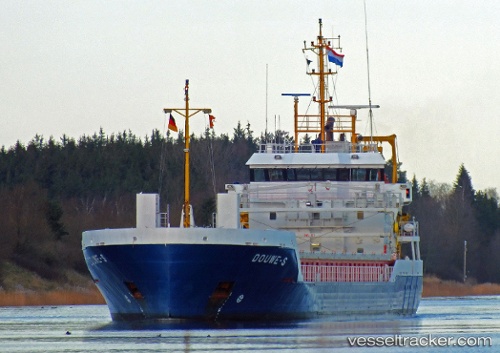
 Douwe s
Current Status
Where is the vessel?
Douwe s is currently in Near Smalkalden, based on AIS data received about 14h ago.
Latest AIS update:
Current position: 5.63965° N, 55.06763° W (Near Smalkalden)
Average speed (last 7 days): Loading…
Average speed (last 30 days): Loading…
Vessel profile: Douwe s is a General Cargo Ship with dimensions 95m x 14m.
This page combines live AIS, route history, probable destination signals, nearby traffic, and port activity for practical vessel monitoring.
The current position of vessel Douwe s is 5.63965 lat / -55.06763 lng. Updated: 2026-05-17 20:00:19 UTCNearest reference points:
- Near Paramaribo Zorg en Hoop Airport
- 38 nm NW of Jarikaba
Currently sailing under the flag of Netherlands ![]()
Douwe s built in 2011 year
Deadweight:
3637 tDetails:
Live Vessel Douwe s Analytics (details, animations, etc.)
Recent AIS points (UTC):
2026-05-17 16:24:20 UTC · 5.64147, -55.06703 · SOG 0 kn · COG 192°2026-05-17 17:27:18 UTC · 5.64140, -55.06710 · SOG 0 kn · COG 180°
2026-05-17 19:03:19 UTC · 5.63979, -55.06778 · SOG 0.1 kn · COG 34°
2026-05-17 20:00:19 UTC · 5.63965, -55.06763 · SOG 0 kn · COG 31°