 PRINCESS MARIA
Current Status
Where is the vessel?
PRINCESS MARIA is currently in Near JINGTANG, based on AIS data received about 14h ago.
Latest AIS update:
Current position: 39.13964° N, 119.12252° E (Near JINGTANG)
Average speed (last 7 days): Loading…
Average speed (last 30 days): Loading…
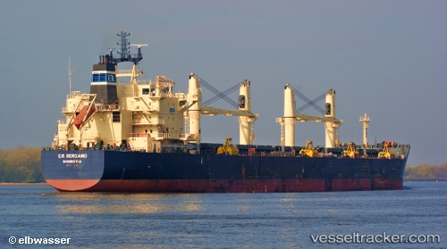
Vessel profile: PRINCESS MARIA is a Bulk Carrier with dimensions 187m x 32m.
This page combines live AIS, route history, probable destination signals, nearby traffic, and port activity for practical vessel monitoring.
The current position of vessel PRINCESS MARIA is 39.13964 lat / 119.12252 lng. Updated: 2026-05-21 17:45:39 UTCNearest reference points:
- Near JINGTANG
- 19 nm SE of JINGTANG
- 28 nm SE of JINGTANG
Currently sailing under the flag of Marshall Islands ![]()
PRINCESS MARIA built in 2009 year
Deadweight:
55783 tDetails:
Live Vessel PRINCESS MARIA Analytics (details, animations, etc.)
Recent AIS points (UTC):
2026-05-21 13:48:39 UTC · 39.14086, 119.12525 · SOG 0 kn · COG 196°2026-05-21 16:03:38 UTC · 39.14058, 119.12330 · SOG 0 kn · COG 143°
2026-05-21 16:06:40 UTC · 39.14052, 119.12323 · SOG 0 kn · COG 140°
2026-05-21 17:45:39 UTC · 39.13964, 119.12252 · SOG 0 kn · COG 103°