 vesseltracker.com
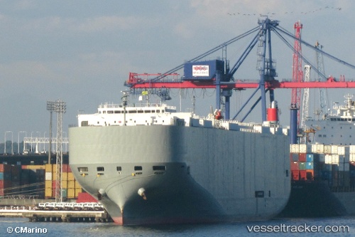
 Brasilia Highway
Current Status
Where is the vessel?
Brasilia Highway is currently in 15 nm NE of Magdalena, based on AIS data received about 14h ago.
Latest AIS update:
Current position: 34.79851° S, 57.47147° W (15 nm NE of Magdalena)
Average speed (last 7 days): Loading…
Average speed (last 30 days): Loading…
Vessel profile: Brasilia Highway is a Vehicles Carrier with dimensions 199m x 32m.
This page combines live AIS, route history, probable destination signals, nearby traffic, and port activity for practical vessel monitoring.
The current position of vessel Brasilia Highway is -34.79851 lat / -57.47147 lng. Updated: 2026-05-18 01:18:30 UTCNearest reference points:
- Near JUAN LACAZE
- Near Dock Sur
- Near Avellaneda
Currently sailing under the flag of Panama ![]()
Brasilia Highway built in 2009 year
Deadweight:
18793 tDetails:
Live Vessel Brasilia Highway Analytics (details, animations, etc.)
Recent AIS points (UTC):
2026-05-17 22:05:16 UTC · -34.64643, -58.08445 · SOG 15.4 kn · COG 117°2026-05-17 22:13:00 UTC · -34.65857, -58.04720 · SOG 15.6 kn · COG 108°
2026-05-18 00:23:27 UTC · -34.74815, -57.64024 · SOG 6.4 kn · COG 106°
2026-05-18 01:18:30 UTC · -34.79851, -57.47147 · SOG 13.1 kn · COG 125°