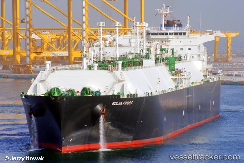
.
Vessel photo of Golar Frost (IMO 9655042) vesseltracker.com

Golar Frost

Vessel type: Lng Tanker | IMO: 9655042 | MMSI: MMSI: 538004975
Call sign: V7AE2 | Dimensions: 42 m x 280 m
Current Status

Where is the vessel?

Golar Frost is currently in 43 nm SE of Nishitokyo, based on AIS data received about 14h ago.

Latest AIS update:

Current position: 34.15486° N, 140.04308° E (43 nm SE of Nishitokyo)

Average speed (last 7 days): Loading…

Average speed (last 30 days): Loading…

Vessel profile: Golar Frost is a Lng Tanker with dimensions 42m x 280m.

This page combines live AIS, route history, probable destination signals, nearby traffic, and port activity for practical vessel monitoring.

The current position of vessel Golar Frost is 34.15486 lat / 140.04308 lng. Updated: 2026-05-18 02:05:11 UTC
More recent position available: 30 min ago

Shipinfo shows free vessel positions with a delay. After payment, you will be able to view the current position of this vessel for 24 hours.

We recommend registering. If you register, paid vessel access will be saved in your profile. Guest access works only through a personal link.

Nearest reference points:
  • Near Nishitokyo
  • Near Toshima/Tokyo
  • 15 nm S of Zushi
Details:

Live Vessel Golar Frost Analytics (details, animations, etc.)


Recent AIS points (UTC):
2026-05-17 21:30:14 UTC · 33.24667, 139.38499 · SOG 14 kn · COG -1°
2026-05-17 22:48:15 UTC · 33.48167, 139.65334 · SOG 15 kn · COG -1°
2026-05-17 23:42:14 UTC · 33.63667, 139.85333 · SOG 15 kn · COG -1°
2026-05-18 02:05:11 UTC · 34.15486, 140.04308 · SOG 14.4 kn · COG 339°

UTC: --
Start: -- Track timeline (UTC) End: --
Encountered: --


Link to the map:


Find another ship

Golar_Frost (538004975) last ports (portcalls and passsages)

TANAH MERAH | 2025-08-30 04:38:07
BATU AMPAR | 2025-08-30 03:45:07
PULAU SAMBU | 2025-08-30 03:08:04
Rio Haina | 2025-07-24 14:49:49
BUKOM ISLAND | 2025-06-10 08:44:50
TANAH MERAH | 2025-06-10 07:52:26
PENGERANG | 2025-06-10 06:56:22
XIANTOULING | 2025-06-05 02:24:20
PENGERANG | 2025-05-26 06:54:06
TANAH MERAH | 2025-05-26 04:33:25
BATU AMPAR | 2025-05-26 04:09:57
RAS LAFFAN | 2025-05-14 04:10:54
Galle | 2025-05-01 04:00:51
JURONG ISLAND | 2025-04-13 03:02:53
TANAH MERAH | 2025-04-13 00:55:50
PENGERANG | 2025-04-12 23:48:57
DAECHEONHANG | 2025-02-24 04:26:50
BINTULU | 2025-02-10 00:24:45
BINTULU | 2025-01-21 02:57:10
PENGERANG | 2024-12-24 04:28:25
Singapore | 2024-12-24 01:41:51
PULAU SAMBU | 2024-12-24 01:18:23
POINT FORTIN | 2024-11-24 07:09:02
HOEK VAN HOLLAND | 2024-11-04 19:24:13
MAASVLAKTE - ROTTERDAM | 2024-11-04 18:43:48
Map Ta Phut | 2024-09-05 22:50:13
Gladstone Harbor | 2024-08-16 00:36:14
Da Chan Bay | 2024-07-15 05:36:39
Da Chan Bay | 2024-07-11 05:31:00
Da Chan Bay | 2024-07-07 05:26:11
Da Chan Bay | 2024-07-03 04:51:10
Da Chan Bay | 2024-06-26 07:26:38
Shekou | 2024-06-26 05:47:52
Selat Lombok | 2024-05-27 12:35:55
Batangas | 2024-05-20 00:32:56
Singapore | 2024-05-10 22:11:18
Gladstone Harbor | 2024-04-09 03:20:22
Map Ta Phut | 2024-03-12 23:47:46
St. Georges | 2024-02-12 08:55:30
Singapore | 2023-12-20 22:08:01
Map Ta Phut | 2023-12-17 07:19:51
Port Louis | 2023-10-07 00:34:33
Singapore | 2023-09-28 13:21:33
Higashi-Iwase | 2023-09-20 03:43:04
Kobe | 2023-09-19 05:13:00
Selat Lombok | 2023-07-27 03:06:50
Map Ta Phut | 2023-07-18 23:36:46
Singapore | 2023-07-05 05:41:28
Sambu | 2023-07-05 05:24:54
Algeciras | 2023-04-27 23:14:42
Strait Of Gibraltar | 2023-04-27 03:44:48
Calais | 2023-02-18 08:08:17
Port Louis | 2023-01-12 11:55:12
Oita | 2022-08-12 01:30:45
Singapore | 2022-06-29 04:47:50
Yosu | 2022-06-21 22:58:28
Yokosuka | 2022-06-10 04:26:31
Yokohama | 2022-06-09 01:32:11
Subic Bay | 2022-04-10 07:15:11
Subic Bay | 2022-04-10 00:18:09
Yokkaichi | 2022-02-21 03:35:04
Higashi-Iwase | 2022-01-24 04:50:03
Panama | 2021-12-29 23:55:20
Panama | 2021-12-29 23:40:20
Balboa | 2021-12-29 19:40:09
Cristobal | 2021-12-28 13:00:02