 vesseltracker.com
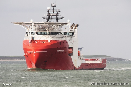
 SIEM STINGRAY
Current Status
Where is the vessel?
SIEM STINGRAY is currently in 20 nm N of Vilje, based on AIS data received about 15h ago.
Latest AIS update:
Current position: 59.99928° N, 2.36972° E (20 nm N of Vilje)
Average speed (last 7 days): Loading…
Average speed (last 30 days): Loading…
Vessel profile: SIEM STINGRAY is a Other Type with dimensions m x m.
This page combines live AIS, route history, probable destination signals, nearby traffic, and port activity for practical vessel monitoring.
The current position of vessel SIEM STINGRAY is 59.99928 lat / 2.36972 lng. Updated: 2026-05-18 11:53:58 UTCNearest reference points:
- 10 nm N of Leadon
- Near Alba Oil Field
Currently sailing under the flag of Bahamas ![]()
Details:
Live Vessel SIEM STINGRAY Analytics (details, animations, etc.)
Recent AIS points (UTC):
2026-05-18 07:50:07 UTC · 59.99914, 2.36968 · SOG 0.1 kn · COG 135°2026-05-18 09:48:48 UTC · 59.99914, 2.36969 · SOG 0.2 kn · COG 134°
2026-05-18 10:46:07 UTC · 59.99913, 2.36968 · SOG 0.1 kn · COG 135°
2026-05-18 11:53:58 UTC · 59.99928, 2.36972 · SOG 0.2 kn · COG 135°