 vesseltracker.com
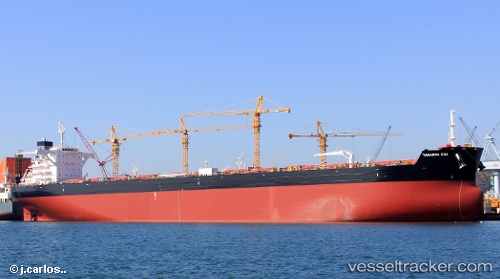
Taharoa Eos
Current StatusWhere is the vessel?
Taharoa Eos is currently in 366 nm S of Ile des Pins, based on AIS data received about 14h ago.
Latest AIS update:
Current position: 28.66200° S, 168.04872° E (366 nm S of Ile des Pins)
Average speed (last 7 days): Loading…
Average speed (last 30 days): Loading…
Vessel profile: Taharoa Eos is a Ore Carrier with dimensions 45m x 290m.
This page combines live AIS, route history, probable destination signals, nearby traffic, and port activity for practical vessel monitoring.
The current position of vessel Taharoa Eos is -28.66200 lat / 168.04872 lng. Updated: 2026-05-18 07:38:56 UTCNearest reference points:
- Open sea, approx. 416 nm off the nearest listed port
- Open sea, approx. 419 nm off the nearest listed port
- Open sea, approx. 422 nm off the nearest listed port
Details:
Live Vessel Taharoa Eos Analytics (details, animations, etc.)
Recent AIS points (UTC):
2026-05-18 04:05:37 UTC · -29.22420, 168.41676 · SOG 10.9 kn · COG 329°2026-05-18 04:21:17 UTC · -29.18283, 168.38966 · SOG 10.9 kn · COG 329°
2026-05-18 05:59:20 UTC · -28.92333, 168.22333 · SOG 10 kn · COG -1°
2026-05-18 07:38:56 UTC · -28.66200, 168.04872 · SOG 11 kn · COG 329°