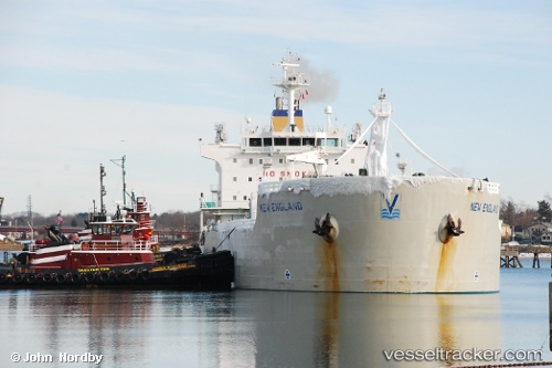
 New England
Current Status
Where is the vessel?
New England is currently in Near CANAPORT LNG, based on AIS data received about 14h ago.
Latest AIS update:
Current position: 45.15653° N, 66.11397° W (Near CANAPORT LNG)
Average speed (last 7 days): Loading…
Average speed (last 30 days): Loading…
Vessel profile: New England is a Chemical Oil Products Tanker with dimensions 182m x 182m.
This page combines live AIS, route history, probable destination signals, nearby traffic, and port activity for practical vessel monitoring.
The current position of vessel New England is 45.15653 lat / -66.11397 lng. Updated: 2026-05-29 10:10:52 UTCNearest reference points:
- Near St. John
- Near Tiverton
- 16 nm W of Tiverton
Currently sailing under the flag of Marshall Is ![]()
New England built in 2005 year
Deadweight:
37515 tDetails:
Live Vessel New England Analytics (details, animations, etc.)
Recent AIS points (UTC):
2026-05-29 07:16:28 UTC · 45.15680, -66.11613 · SOG 0.1 kn · COG 31°2026-05-29 07:26:18 UTC · 45.15664, -66.11563 · SOG 0.1 kn · COG 30°
2026-05-29 09:55:53 UTC · 45.15671, -66.11330 · SOG 0.1 kn · COG 332°
2026-05-29 10:10:52 UTC · 45.15653, -66.11397 · SOG 0.3 kn · COG 1°