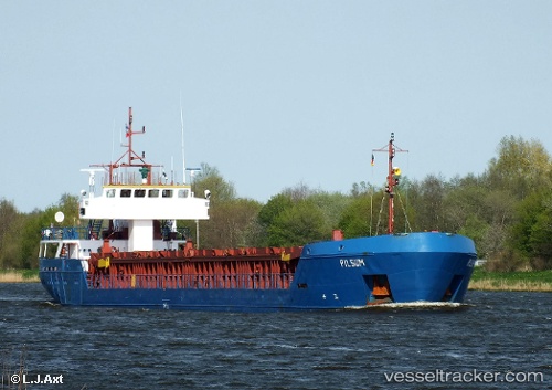
 VULIN
VULIN
Current Status
Where is the vessel?
VULIN is currently in Near GENT, based on AIS data received about 15h ago.
Latest AIS update:
Current position: 51.09022° N, 3.73687° E (Near GENT)
Average speed (last 7 days): Loading…
Average speed (last 30 days): Loading…
Vessel profile: VULIN is a General Cargo with dimensions m x m.
This page combines live AIS, route history, probable destination signals, nearby traffic, and port activity for practical vessel monitoring.
The current position of vessel VULIN is 51.09022 lat / 3.73687 lng. Updated: 2026-05-22 02:07:53 UTCNearest reference points:
- Near Oostakker
- Near Rieme
- Near Landegem
Currently sailing under the flag of Saint Kitts and Nevis ![]()
Details:
Live Vessel VULIN Analytics (details, animations, etc.)
Recent AIS points (UTC):
2026-05-21 21:53:59 UTC · 51.09089, 3.73550 · SOG 2 kn · COG 114°2026-05-21 22:07:47 UTC · 51.09025, 3.73680 · SOG 0 kn · COG 111°
2026-05-22 01:25:50 UTC · 51.09027, 3.73685 · SOG 0 kn · COG 113°
2026-05-22 02:07:53 UTC · 51.09022, 3.73687 · SOG 0 kn · COG 113°