 vesseltracker.com
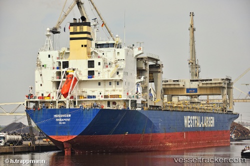
 HOSANGER
Current Status
Where is the vessel?
HOSANGER is currently in Near Waterport, based on AIS data received less than 1h ago.
Latest AIS update:
Current position: 36.12874° N, 5.36514° W (Near Waterport)
Average speed (last 7 days): Loading…
Average speed (last 30 days): Loading…
Vessel profile: HOSANGER is a General Cargo Ship with dimensions 31m x 213m.
This page combines live AIS, route history, probable destination signals, nearby traffic, and port activity for practical vessel monitoring.
The current position of vessel HOSANGER is 36.12874 lat / -5.36514 lng. Updated: 2026-05-01 22:31:50 UTCNearest reference points:
- Near Waterport
- Near La Línea de la Concepción
- Near Palmones
Currently sailing under the flag of Marshall Islands ![]()
HOSANGER built in 1995 year
Deadweight:
50198 tDetails:
Live Vessel HOSANGER Analytics (details, animations, etc.)
Recent AIS points (UTC):
2026-05-01 19:12:39 UTC · 36.12284, -5.36270 · SOG 0.1 kn · COG 352°2026-05-01 19:55:42 UTC · 36.12269, -5.36350 · SOG 0.1 kn · COG 11°
2026-05-01 22:06:57 UTC · 36.12870, -5.36549 · SOG 0.1 kn · COG 157°
2026-05-01 22:31:50 UTC · 36.12874, -5.36514 · SOG 0.1 kn · COG 171°