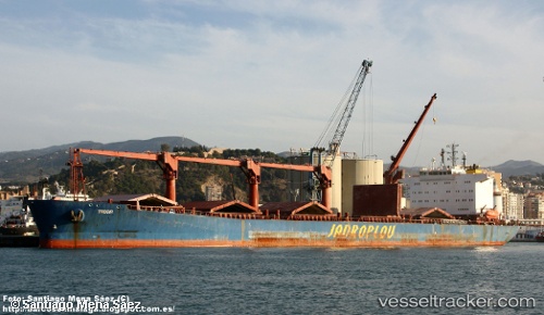
 Trogir
Current Status
Where is the vessel?
Trogir is currently in Near Aliaga, based on AIS data received about 14h ago.
Latest AIS update:
Current position: 38.84268° N, 26.89933° E (Near Aliaga)
Average speed (last 7 days): Loading…
Average speed (last 30 days): Loading…
Vessel profile: Trogir is a Bulk Carrier with dimensions 183m x 183m.
This page combines live AIS, route history, probable destination signals, nearby traffic, and port activity for practical vessel monitoring.
The current position of vessel Trogir is 38.84268 lat / 26.89933 lng. Updated: 2026-05-21 01:02:19 UTCNearest reference points:
- Near Aliaga
- Near Nemrut Bay
- Near NEMRUT
Currently sailing under the flag of Croatia ![]()
Trogir built in 2001 year
Deadweight:
44314 tDetails:
Live Vessel Trogir Analytics (details, animations, etc.)
Recent AIS points (UTC):
2026-05-20 21:51:29 UTC · 38.84079, 26.89636 · SOG 0.1 kn · COG 103°2026-05-20 22:15:50 UTC · 38.84107, 26.89632 · SOG 0.1 kn · COG 113°
2026-05-21 00:19:19 UTC · 38.84258, 26.89839 · SOG 0 kn · COG 178°
2026-05-21 01:02:19 UTC · 38.84268, 26.89933 · SOG 0.2 kn · COG 186°