 BOSHI 56
Current Status
Where is the vessel?
BOSHI 56 is currently in 210 nm SE of Aracaju, based on AIS data received about 14h ago.
Latest AIS update:
Current position: 13.23319° S, 34.25001° W (210 nm SE of Aracaju)
Average speed (last 7 days): Loading…
Average speed (last 30 days): Loading…
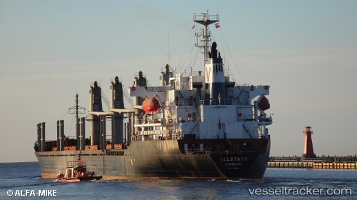
Vessel profile: BOSHI 56 is a Bulk Carrier with dimensions 165m x 31m.
This page combines live AIS, route history, probable destination signals, nearby traffic, and port activity for practical vessel monitoring.
The current position of vessel BOSHI 56 is -13.23319 lat / -34.25001 lng. Updated: 2026-05-24 18:01:55 UTCNearest reference points:
- 157 nm SE of Maceio
Currently sailing under the flag of Panama ![]()
BOSHI 56 built in 2000 year
Deadweight:
28520 tDetails:
Live Vessel BOSHI 56 Analytics (details, animations, etc.)
Recent AIS points (UTC):
2026-05-24 14:12:34 UTC · -12.61982, -33.86566 · SOG 10.9 kn · COG 207°2026-05-24 15:53:55 UTC · -12.88971, -34.03755 · SOG 11.2 kn · COG 207°
2026-05-24 16:39:56 UTC · -13.01210, -34.11251 · SOG 11.2 kn · COG 208°
2026-05-24 18:01:55 UTC · -13.23319, -34.25001 · SOG 11.4 kn · COG 207°