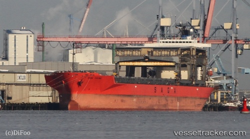
 SAGA VIKING
Current Status
Where is the vessel?
SAGA VIKING is currently in Near Elleholm, based on AIS data received about 14h ago.
Latest AIS update:
Current position: 56.15672° N, 14.81824° E (Near Elleholm)
Average speed (last 7 days): Loading…
Average speed (last 30 days): Loading…
Vessel profile: SAGA VIKING is a General Cargo with dimensions m x m.
This page combines live AIS, route history, probable destination signals, nearby traffic, and port activity for practical vessel monitoring.
The current position of vessel SAGA VIKING is 56.15672 lat / 14.81824 lng. Updated: 2026-07-02 15:58:10 UTCNearest reference points:
- Near Sölvesborg
- Near RONNEBY
- Near Åhus
Currently sailing under the flag of Bahamas ![]()
Details:
Live Vessel SAGA VIKING Analytics (details, animations, etc.)
Recent AIS points (UTC):
2026-07-02 11:31:10 UTC · 56.15672, 14.81825 · SOG 0 kn · COG 192°2026-07-02 13:10:10 UTC · 56.15672, 14.81825 · SOG 0 kn · COG 192°
2026-07-02 14:16:10 UTC · 56.15670, 14.81826 · SOG 0 kn · COG 192°
2026-07-02 15:58:10 UTC · 56.15672, 14.81824 · SOG 0 kn · COG 192°