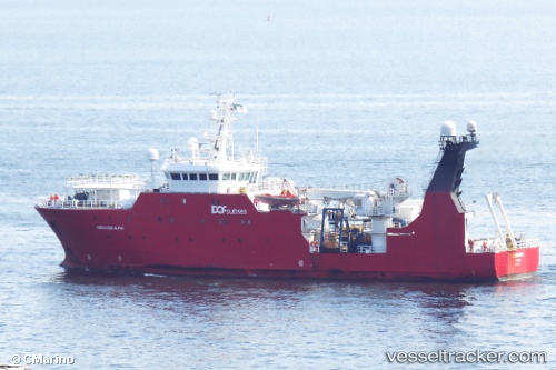
 OCEAN GEOGRAPH
Current Status
Where is the vessel?
OCEAN GEOGRAPH is currently in 39 nm N of Snohvit, based on AIS data received about 14h ago.
Latest AIS update:
Current position: 72.24322° N, 20.96058° E (39 nm N of Snohvit)
Average speed (last 7 days): Loading…
Average speed (last 30 days): Loading…
Vessel profile: OCEAN GEOGRAPH is a Research/Survey Vessel with dimensions m x m.
This page combines live AIS, route history, probable destination signals, nearby traffic, and port activity for practical vessel monitoring.
The current position of vessel OCEAN GEOGRAPH is 72.24322 lat / 20.96058 lng. Updated: 2026-05-24 13:31:44 UTCNearest reference points:
- 40 nm SW of Snohvit
- Near SORVAR
- Near Skjervøy
Currently sailing under the flag of Bahamas ![]()
Details:
Live Vessel OCEAN GEOGRAPH Analytics (details, animations, etc.)
Recent AIS points (UTC):
2026-05-24 11:01:24 UTC · 72.23930, 20.76070 · SOG 4.5 kn · COG 279°2026-05-24 11:58:56 UTC · 72.25983, 20.59626 · SOG 4.5 kn · COG 75°
2026-05-24 13:31:44 UTC · 72.24322, 20.96058 · SOG 4.3 kn · COG 99°
2026-05-24 13:31:44 UTC · 72.24322, 20.96058 · SOG 4.3 kn · COG 99°