 vesseltracker.com
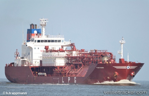
 Thetagas
Current Status
Where is the vessel?
Thetagas is currently in Near Fos-sur-Mer, based on AIS data received less than 1h ago.
Latest AIS update:
Current position: 43.40858° N, 4.93907° E (Near Fos-sur-Mer)
Average speed (last 7 days): Loading…
Average speed (last 30 days): Loading…
Vessel profile: Thetagas is a Lpg Tanker with dimensions 120m x 20m.
This page combines live AIS, route history, probable destination signals, nearby traffic, and port activity for practical vessel monitoring.
The current position of vessel Thetagas is 43.40858 lat / 4.93907 lng. Updated: 2026-05-13 01:21:55 UTCNearest reference points:
- Near Fos-sur-Mer
- Near SAINT LOUIS DU RHONE
- Near Marseille
Currently sailing under the flag of Antigua Barbuda ![]()
Details:
Live Vessel Thetagas Analytics (details, animations, etc.)
Recent AIS points (UTC):
2026-05-12 21:51:55 UTC · 43.40862, 4.93913 · SOG 0.1 kn · COG 331°2026-05-12 22:24:55 UTC · 43.40862, 4.93918 · SOG 0.1 kn · COG 325°
2026-05-12 23:21:55 UTC · 43.40865, 4.93920 · SOG 0 kn · COG 329°
2026-05-13 01:21:55 UTC · 43.40858, 4.93907 · SOG 0.1 kn · COG 335°