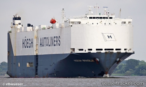
 VIKING BRASILIA
Current Status
Where is the vessel?
VIKING BRASILIA is currently in 135 nm NW of Munshiganj, based on AIS data received about 15h ago.
Latest AIS update:
Current position: 25.54833° N, 91.67833° W (135 nm NW of Munshiganj)
Average speed (last 7 days): Loading…
Average speed (last 30 days): Loading…
Vessel profile: VIKING BRASILIA is a Vehicles Carrier with dimensions m x m.
This page combines live AIS, route history, probable destination signals, nearby traffic, and port activity for practical vessel monitoring.
The current position of vessel VIKING BRASILIA is 25.54833 lat / -91.67833 lng. Updated: 2026-05-26 02:04:08 UTCNearest reference points:
- 124 nm SW of Gulfmex Lightering Area
- 94 nm S of Gulfmex Lightering Area
- 83 nm W of Gulfmex Lightering Area
Currently sailing under the flag of Marshall Islands ![]()
Details:
Live Vessel VIKING BRASILIA Analytics (details, animations, etc.)
Recent AIS points (UTC):
2026-05-25 22:52:08 UTC · 25.18167, -90.97667 · SOG 13 kn · COG -1°2026-05-25 23:55:10 UTC · 25.29333, -91.20833 · SOG 13 kn · COG -1°
2026-05-26 01:19:06 UTC · 25.45500, -91.51500 · SOG 13 kn · COG -1°
2026-05-26 02:04:08 UTC · 25.54833, -91.67833 · SOG 14 kn · COG -1°