 vesseltracker.com
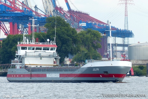
 JOLYN
JOLYN
Current Status
Where is the vessel?
JOLYN is currently in 28 nm SE of Mörbylånga, based on AIS data received less than 1h ago.
Latest AIS update:
Current position: 56.33017° N, 17.15013° E (28 nm SE of Mörbylånga)
Average speed (last 7 days): Loading…
Average speed (last 30 days): Loading…
Vessel profile: JOLYN is a General Cargo Ship with dimensions 90m x 13m.
This page combines live AIS, route history, probable destination signals, nearby traffic, and port activity for practical vessel monitoring.
The current position of vessel JOLYN is 56.33017 lat / 17.15013 lng. Updated: 2026-05-15 19:54:48 UTCNearest reference points:
- 31 nm NW of Ustka
- Near Karlskrona
- Near RONNEBY
Currently sailing under the flag of Netherlands ![]()
JOLYN built in 2007 year
Deadweight:
3636 tDetails:
Live Vessel JOLYN Analytics (details, animations, etc.)
Recent AIS points (UTC):
2026-05-15 16:39:09 UTC · 56.69131, 17.97412 · SOG 11 kn · COG 232°2026-05-15 17:53:10 UTC · 56.55585, 17.65281 · SOG 10.6 kn · COG 232°
2026-05-15 19:08:48 UTC · 56.41579, 17.33732 · SOG 10.5 kn · COG 231°
2026-05-15 19:54:48 UTC · 56.33017, 17.15013 · SOG 10.5 kn · COG 230°