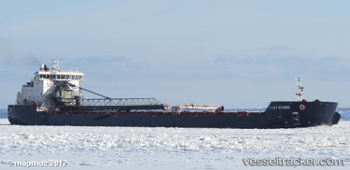
 Algoma Mariner
Current Status
Where is the vessel?
Algoma Mariner is currently in 76 nm W of Port Royal, based on AIS data received about 15h ago.
Latest AIS update:
Current position: 31.92667° N, 78.58333° W (76 nm W of Port Royal)
Average speed (last 7 days): Loading…
Average speed (last 30 days): Loading…
Vessel profile: Algoma Mariner is a Self Discharging Bulk Carrier with dimensions 225m x 225m.
This page combines live AIS, route history, probable destination signals, nearby traffic, and port activity for practical vessel monitoring.
The current position of vessel Algoma Mariner is 31.92667 lat / -78.58333 lng. Updated: 2026-07-04 13:02:45 UTCNearest reference points:
- 33 nm S of Kiawah Island
- Near Charleston
- Near North Myrtle Beach
Currently sailing under the flag of Canada ![]()
Algoma Mariner built in 2011 year
Deadweight:
37690 tDetails:
Live Vessel Algoma Mariner Analytics (details, animations, etc.)
Recent AIS points (UTC):
2026-07-04 10:23:25 UTC · 31.55333, -79.03833 · SOG 13 kn · COG -1°2026-07-04 11:05:31 UTC · 31.65333, -78.91667 · SOG 12 kn · COG -1°
2026-07-04 13:02:45 UTC · 31.92667, -78.58333 · SOG 12 kn · COG -1°
2026-07-04 13:02:45 UTC · 31.92667, -78.58333 · SOG 12 kn · COG -1°