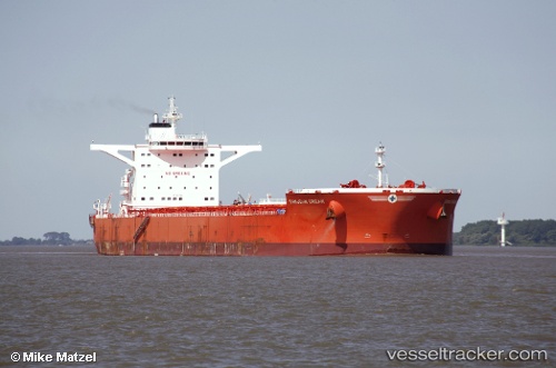
.
Vessel photo of Samjohn Dream (IMO 9612064) vesseltracker.com

Samjohn Dream

Vessel type: Bulk Carrier | IMO: 9612064 | MMSI: MMSI: 538007338
Call sign: V7KF3 | Dimensions: 50 m x 300 m
Current Status

Where is the vessel?

Samjohn Dream is currently in 26 nm S of SEPETIBA, based on AIS data received less than 1h ago.

Latest AIS update:

Current position: 23.40224° S, 43.59197° W (26 nm S of SEPETIBA)

Average speed (last 7 days): Loading…

Average speed (last 30 days): Loading…

Vessel profile: Samjohn Dream is a Bulk Carrier with dimensions 50m x 300m.

This page combines live AIS, route history, probable destination signals, nearby traffic, and port activity for practical vessel monitoring.

The current position of vessel Samjohn Dream is -23.40224 lat / -43.59197 lng. Updated: 2026-04-09 00:19:18 UTC
Nearest reference points:
  • 27 nm SW of Santos Dumont Apt/Rio de Janeiro
  • 49 nm S of SEPETIBA
  • Near ILHA GUAIBA
Details:

Live Vessel Samjohn Dream Analytics (details, animations, etc.)


Recent AIS points (UTC):
2026-04-08 16:17:33 UTC · -22.93666, -43.82849 · SOG 0 kn · COG 266°
2026-04-08 18:15:07 UTC · -22.93664, -43.82837 · SOG 0 kn · COG 266°
2026-04-08 19:54:34 UTC · -22.99744, -43.98585 · SOG 8.8 kn · COG 243°
2026-04-09 00:19:18 UTC · -23.40224, -43.59197 · SOG 9.8 kn · COG 115°

Track of the vessel in the last 60 days


UTC: --
Start: -- Track timeline (UTC) End: --
Encountered: --


Link to the map:


Find another ship

Samjohn_Dream (538007338) last ports (portcalls and passsages)

BATU AMPAR | 2025-07-15 11:19:39
TANAH MERAH | 2025-07-14 16:56:59
PENGERANG | 2025-07-14 14:56:31
HUANGHUA | 2025-07-02 09:39:08
HUANGHUA | 2025-06-26 19:58:27
PENGERANG | 2025-06-15 15:47:16
TANAH MERAH | 2025-06-13 13:09:34
PULAU SAMBU | 2025-06-13 10:38:22
Sebang | 2025-06-10 14:11:17
PULAU SAMBU | 2025-02-03 05:01:36
TANAH MERAH | 2025-02-02 00:54:18
PENGERANG | 2025-02-01 23:36:50
DONGJIAKOU | 2025-01-21 13:24:50
Selat Lombok | 2025-01-09 21:24:39
Port Headland | 2025-01-05 00:04:02
Selat Lombok | 2024-12-21 08:04:49
Dagu Bar | 2024-12-06 23:03:08
Taku Bar | 2024-12-06 22:22:13
Selat Lombok | 2024-11-21 04:29:36
Port Headland | 2024-11-17 05:06:26
Qingdao | 2024-10-25 21:16:24
Lianyungang | 2024-10-18 03:24:27
Vitoria | 2024-08-31 22:00:39
Tubarao | 2024-08-30 09:32:05
Singapore | 2024-07-27 03:04:11
Shimotsui | 2024-06-26 02:33:42
Samson Point | 2024-06-08 12:15:30
Selat Lombok | 2024-06-02 05:01:17
Lianyungang | 2024-05-20 00:13:50
Selat Lombok | 2024-05-04 07:45:51
Port Headland | 2024-04-30 10:30:08
Singapore | 2024-04-02 07:43:26
Sambu | 2024-04-02 07:09:05
Singapore | 2023-12-17 08:46:02
Tubarao | 2023-11-12 08:07:25
Tubarao | 2023-11-08 07:57:25
Singapore | 2023-10-06 08:48:12
Singapore | 2023-09-05 22:25:40
Ra’S Shukhayr | 2023-08-18 04:30:42
Ras Gharib | 2023-08-18 03:05:03
Bur Ibrahim | 2023-08-17 18:04:35
Strait Of Gibraltar | 2023-08-08 23:39:48
Sept Iles | 2023-07-27 16:19:10
Sept Iles | 2023-07-23 15:28:55
Sept Iles | 2023-07-19 15:09:12
Saldanha Bay | 2023-06-11 09:44:49
Saldanha Bay | 2023-06-06 18:34:01
Saldanha Bay | 2023-05-28 10:17:23
Rizhao | 2023-04-20 17:24:39
Ta-Ku | 2023-04-18 11:40:01
Dagu Bar | 2023-04-17 02:42:39
Taku Bar | 2023-04-17 01:50:30
Port Headland | 2023-03-25 11:30:06
Qingdao | 2023-03-02 05:32:06
Singapore | 2022-12-02 12:03:20
Sambu | 2022-04-08 04:08:34
Singapore | 2022-03-12 21:15:24
Selat Lombok | 2022-02-13 23:53:10
Port Headland | 2022-02-09 10:00:49
Selat Lombok | 2022-02-05 00:08:24
Taku Bar | 2022-01-24 13:34:26
Taku Bar | 2022-01-24 13:01:26
Dagu Bar | 2022-01-20 07:33:59
Taku Bar | 2022-01-20 06:36:31
Selat Lombok | 2021-12-26 03:41:42
Port Headland | 2021-12-22 11:40:00