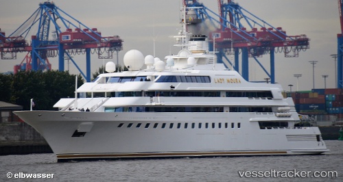
 Lady Moura
Current Status
Where is the vessel?
Lady Moura is currently in Near Yunquera, based on AIS data received about 14h ago.
Latest AIS update:
Current position: 36.71645° N, 4.41416° W (Near Yunquera)
Average speed (last 7 days): Loading…
Average speed (last 30 days): Loading…
Vessel profile: Lady Moura is a Yacht with dimensions 105m x 20m.
This page combines live AIS, route history, probable destination signals, nearby traffic, and port activity for practical vessel monitoring.
The current position of vessel Lady Moura is 36.71645 lat / -4.41416 lng. Updated: 2026-05-22 07:27:11 UTCNearest reference points:
- Near Yunquera
- Near Cala Moral
- Near Arroyo de la Miel
Currently sailing under the flag of Bahamas ![]()
Lady Moura built in 1990 year
Details:
Live Vessel Lady Moura Analytics (details, animations, etc.)
Recent AIS points (UTC):
2026-05-22 04:00:11 UTC · 36.71645, -4.41415 · SOG 0 kn · COG -1°2026-05-22 04:27:12 UTC · 36.71646, -4.41417 · SOG 0 kn · COG -1°
2026-05-22 05:51:10 UTC · 36.71646, -4.41416 · SOG 0 kn · COG -1°
2026-05-22 07:27:11 UTC · 36.71645, -4.41416 · SOG 0 kn · COG -1°