.

CY flag MARIA

Vessel type: Bulk Carrier | IMO: 9568005 | MMSI: MMSI: 210396000
Call sign: 5BYX5 | Dimensions: 45 m x 292 m
Current Status

Where is the vessel?

MARIA is currently in Near Nipah, based on AIS data received about 14h ago.

Latest AIS update:

Current position: 1.14539° N, 103.48131° E (Near Nipah)

Average speed (last 7 days): Loading…

Average speed (last 30 days): Loading…

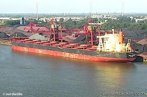
Vessel profile: MARIA is a Bulk Carrier with dimensions 45m x 292m.

This page combines live AIS, route history, probable destination signals, nearby traffic, and port activity for practical vessel monitoring.

The current position of vessel MARIA is 1.14539 lat / 103.48131 lng. Updated: 2026-06-14 23:08:02 UTC
More recent position available: 39 min ago
Free positions are delayed by 14 hours.

We recommend registering. If you register, paid vessel access will be saved in your profile. Guest access works only through a personal link.

Nearest reference points:
  • Near Nipah
  • Near Tanjungbalai
  • Near Tuas

Currently sailing under the flag of Cyprus CY flag

MARIA built in 2014 year

Deadweight:
181343 t

Details:

Live Vessel MARIA Analytics (details, animations, etc.)


Recent AIS points (UTC):
2026-06-14 19:31:02 UTC · 1.41545, 103.12746 · SOG 8.5 kn · COG 130°
2026-06-14 19:45:22 UTC · 1.39773, 103.15529 · SOG 8.3 kn · COG 122°
2026-06-14 22:04:43 UTC · 1.22641, 103.35135 · SOG 8.7 kn · COG 130°
2026-06-14 23:08:02 UTC · 1.14539, 103.48131 · SOG 8.9 kn · COG 121°

Track of the vessel in the last 60 days


UTC: --
Start: -- Track timeline (UTC) End: --
Encountered: --


Link to the map:


Find another ship

MARIA (210396000) last ports (portcalls and passsages)

Lazaro Cardenas | 2025-07-14 02:25:01
Panama | 2025-07-07 22:23:19
PANAMA CITY | 2025-07-07 21:18:11
Rodman | 2025-07-07 18:14:34
COLON 2000 | 2025-07-07 10:06:10
Cristobal | 2025-07-06 18:20:00
PUERTO BOLIVAR | 2025-07-01 17:34:17
Cristobal | 2025-06-29 23:20:27
COLON 2000 | 2025-06-29 22:19:07
PANAMA CITY | 2025-06-28 13:24:45
TABOGA | 2025-06-27 09:25:05
TABOGA | 2025-06-23 08:01:39
Lazaro Cardenas | 2025-06-17 00:58:33
Lazaro Cardenas | 2025-06-13 00:11:27
Lazaro Cardenas | 2025-06-08 23:20:16
Panama | 2025-06-02 21:47:37
PANAMA CITY | 2025-06-02 20:10:24
Rodman | 2025-06-02 18:47:04
COLON 2000 | 2025-06-02 08:35:28
Cristobal | 2025-05-30 07:21:25
PUERTO BOLIVAR | 2025-05-25 21:38:41
PUERTO BOLIVAR | 2025-05-21 21:06:45
COLON 2000 | 2025-05-18 22:01:33
PANAMA CITY | 2025-05-18 10:43:06
TABOGA | 2025-05-16 09:55:18
Taku Bar | 2025-03-14 17:33:36
Selat Lombok | 2025-02-28 04:35:28
Port Headland | 2025-02-23 22:18:53
Selat Lombok | 2025-02-10 22:30:52
WAILINGDING ISLAND | 2025-01-22 08:25:13
Fangcheng | 2025-01-18 03:00:40
Port Headland | 2024-12-31 23:27:00
Selat Lombok | 2024-12-23 08:12:34
ZHANGZHOU | 2024-12-12 15:13:30
Dampier | 2024-11-20 18:39:13
Fangcheng | 2024-11-01 07:21:16
Fangcheng | 2024-10-28 07:17:05
Selat Lombok | 2024-10-17 17:07:17
Port Headland | 2024-10-13 18:09:52
Tsugaru-Kaikyo | 2024-09-15 20:59:00
Panama | 2024-08-15 11:57:01
San Nicolas | 2024-08-06 04:22:11
San Nicolas | 2024-08-02 04:09:46
San Nicolas | 2024-07-29 03:52:50
Tsugaru-Kaikyo | 2024-07-01 14:20:02
Singapore | 2024-06-05 10:42:59
Sambu | 2024-06-05 10:11:16
Nouadhibou | 2024-04-25 08:53:47
Nouadhibou | 2024-04-21 07:26:39
Singapore | 2024-02-25 17:22:03
Selat Lombok | 2024-01-22 00:11:58
Dampier | 2024-01-17 07:35:24
Singapore | 2023-09-04 11:02:40
Dalien | 2023-08-22 07:50:59
Dalien | 2023-08-18 06:33:45
Selat Lombok | 2023-07-30 01:06:07
Port Headland | 2023-07-26 01:18:02
Selat Lombok | 2023-07-23 17:35:34
Rizhao | 2023-07-11 18:15:39
Selat Lombok | 2023-06-27 23:29:46
Port Headland | 2023-06-22 01:18:53
Port Hedland | 2023-06-22 00:27:51
Cape Of Good Hope | 2023-05-08 05:08:28
Saldanha Bay | 2023-05-06 10:08:37
Sambu | 2023-04-15 01:02:03
Dagu Bar | 2023-04-05 04:41:45
Ta-Ku | 2023-04-01 17:09:28
Taku Bar | 2023-04-01 13:17:36
Singapore | 2023-03-19 20:21:58
Richards Bay | 2023-02-28 02:45:34
Singapore | 2022-01-26 05:21:07
Newcastle | 2021-12-17 20:58:08