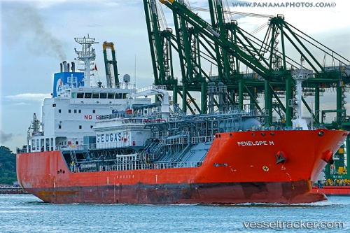
Penelope M
Current StatusWhere is the vessel?
Penelope M is currently in 20 nm NW of Miragoane, based on AIS data received about 15h ago.
Latest AIS update:
Current position: 18.70474° N, 73.33612° W (20 nm NW of Miragoane)
Average speed (last 7 days): Loading…
Average speed (last 30 days): Loading…
Vessel profile: Penelope M is a Lpg Tanker with dimensions 20m x 120m.
This page combines live AIS, route history, probable destination signals, nearby traffic, and port activity for practical vessel monitoring.
The current position of vessel Penelope M is 18.70474 lat / -73.33612 lng. Updated: 2026-06-17 01:41:46 UTCNearest reference points:
- 56 nm SW of Cockburn Harbour
- 47 nm SW of Cockburn Harbour
- 38 nm SW of Cockburn Harbour
Details:
Live Vessel Penelope M Analytics (details, animations, etc.)
Recent AIS points (UTC):
2026-06-16 21:37:08 UTC · 18.70588, -73.35727 · SOG 0.7 kn · COG 166°2026-06-16 23:40:47 UTC · 18.69878, -73.35474 · SOG 0.4 kn · COG 278°
2026-06-17 01:33:47 UTC · 18.70433, -73.33677 · SOG 0.4 kn · COG 287°
2026-06-17 01:41:46 UTC · 18.70474, -73.33612 · SOG 0.3 kn · COG 289°