 vesseltracker.com
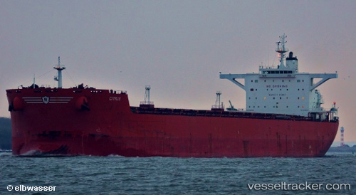
 Citius
Current Status
Where is the vessel?
Citius is currently in 276 nm E of Abakaliki, based on AIS data received less than 1h ago.
Latest AIS update:
Current position: 6.03500° N, 90.60667° E (276 nm E of Abakaliki)
Average speed (last 7 days): Loading…
Average speed (last 30 days): Loading…
Vessel profile: Citius is a Bulk Carrier with dimensions 288m x 45m.
This page combines live AIS, route history, probable destination signals, nearby traffic, and port activity for practical vessel monitoring.
The current position of vessel Citius is 6.03500 lat / 90.60667 lng. Updated: 2026-05-15 18:23:19 UTCNearest reference points:
- 243 nm E of Abakaliki
- 172 nm W of LHOKNGA
- 160 nm W of Sebang
Currently sailing under the flag of United Kingdom ![]()
Citius built in 2010 year
Deadweight:
170024 tDetails:
Live Vessel Citius Analytics (details, animations, etc.)
Recent AIS points (UTC):
2026-05-15 13:59:20 UTC · 6.04667, 91.20500 · SOG 8 kn · COG -1°2026-05-15 15:53:25 UTC · 6.04077, 90.93833 · SOG 8.1 kn · COG 270°
2026-05-15 17:08:25 UTC · 6.04167, 90.76667 · SOG 7 kn · COG -1°
2026-05-15 18:23:19 UTC · 6.03500, 90.60667 · SOG 8 kn · COG -1°