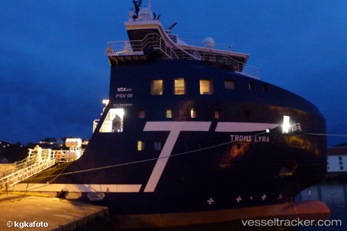
Troms Lyra
Current StatusWhere is the vessel?
Troms Lyra is currently in Near PETERHEAD, based on AIS data received about 14h ago.
Latest AIS update:
Current position: 57.49345° N, 1.78604° W (Near PETERHEAD)
Average speed (last 7 days): Loading…
Average speed (last 30 days): Loading…
Vessel profile: Troms Lyra is a Offshore Tug Supply Ship with dimensions 18m x 82m.
This page combines live AIS, route history, probable destination signals, nearby traffic, and port activity for practical vessel monitoring.
The current position of vessel Troms Lyra is 57.49345 lat / -1.78604 lng. Updated: 2026-05-22 16:30:03 UTCNearest reference points:
- Near PETERHEAD
- Near Peterhead
- Near Aberdeen
Details:
Live Vessel Troms Lyra Analytics (details, animations, etc.)
Recent AIS points (UTC):
2026-05-22 13:56:59 UTC · 57.49338, -1.78601 · SOG 0 kn · COG 138°2026-05-22 14:21:01 UTC · 57.49341, -1.78598 · SOG 0 kn · COG 136°
2026-05-22 16:15:06 UTC · 57.49342, -1.78598 · SOG 0 kn · COG 135°
2026-05-22 16:30:03 UTC · 57.49345, -1.78604 · SOG 0 kn · COG 136°