 vesseltracker.com
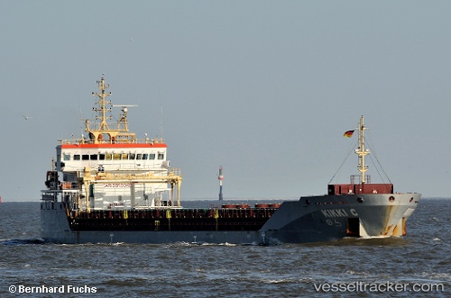
 KIKKI C
Current Status
Where is the vessel?
KIKKI C is currently in 24 nm W of Ile D’Ouessant, based on AIS data received less than 1h ago.
Latest AIS update:
Current position: 48.69282° N, 6.09533° W (24 nm W of Ile D’Ouessant)
Average speed (last 7 days): Loading…
Average speed (last 30 days): Loading…
Vessel profile: KIKKI C is a General Cargo Ship with dimensions 15m x 106m.
This page combines live AIS, route history, probable destination signals, nearby traffic, and port activity for practical vessel monitoring.
The current position of vessel KIKKI C is 48.69282 lat / -6.09533 lng. Updated: 2026-05-14 18:09:44 UTCNearest reference points:
- 16 nm NW of Ile D’Ouessant
- 35 nm SW of Ile D’Ouessant
- 18 nm NE of Ile D’Ouessant
Currently sailing under the flag of Portugal (MAR) ![]()
KIKKI C built in 2011 year
Deadweight:
6796 tDetails:
Live Vessel KIKKI C Analytics (details, animations, etc.)
Recent AIS points (UTC):
2026-05-14 14:07:31 UTC · 49.40300, -6.03917 · SOG 9.7 kn · COG 189°2026-05-14 14:29:51 UTC · 49.34217, -6.03167 · SOG 9.5 kn · COG 187°
2026-05-14 16:29:15 UTC · 49.00617, -6.07650 · SOG 10.2 kn · COG 184°
2026-05-14 18:09:44 UTC · 48.69282, -6.09533 · SOG 11.3 kn · COG 181°