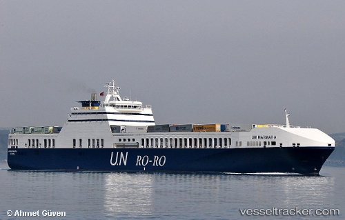
 Un Marmara
Current Status
Where is the vessel?
Un Marmara is currently in 29 nm NW of Psará, based on AIS data received about 14h ago.
Latest AIS update:
Current position: 38.93443° N, 25.21223° E (29 nm NW of Psará)
Average speed (last 7 days): Loading…
Average speed (last 30 days): Loading…
Vessel profile: Un Marmara is a Ro Ro Cargo Ship with dimensions 193m x 26m.
This page combines live AIS, route history, probable destination signals, nearby traffic, and port activity for practical vessel monitoring.
The current position of vessel Un Marmara is 38.93443 lat / 25.21223 lng. Updated: 2026-05-20 13:05:07 UTCNearest reference points:
- 29 nm SW of Sigri Lesvou
- 28 nm NW of Psará
- 16 nm E of Skíros
Currently sailing under the flag of Turkey ![]()
Un Marmara built in 2005 year
Deadweight:
9481 tDetails:
Live Vessel Un Marmara Analytics (details, animations, etc.)
Recent AIS points (UTC):
2026-05-20 10:15:43 UTC · 39.75398, 25.74104 · SOG 19.7 kn · COG 206°2026-05-20 10:15:43 UTC · 39.75398, 25.74104 · SOG 19.7 kn · COG 206°
2026-05-20 11:36:13 UTC · 39.35794, 25.50189 · SOG 19.5 kn · COG 206°
2026-05-20 13:05:07 UTC · 38.93443, 25.21223 · SOG 19.2 kn · COG 209°