 vesseltracker.com
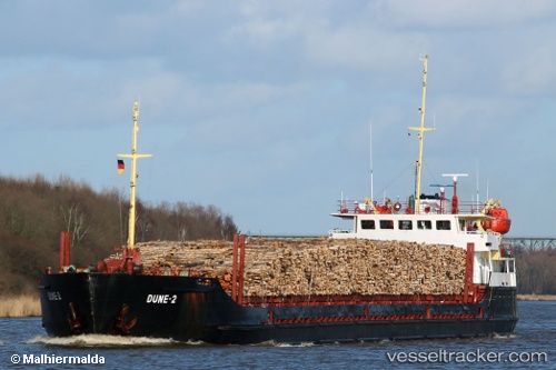
 DUNE 2
Current Status
Where is the vessel?
DUNE 2 is currently in 63 nm S of Olya, based on AIS data received about 1h ago.
Latest AIS update:
Current position: 44.73833° N, 47.71500° E (63 nm S of Olya)
Average speed (last 7 days): Loading…
Average speed (last 30 days): Loading…
Vessel profile: DUNE 2 is a General Cargo Ship with dimensions 13m x 114m.
This page combines live AIS, route history, probable destination signals, nearby traffic, and port activity for practical vessel monitoring.
The current position of vessel DUNE 2 is 44.73833 lat / 47.71500 lng. Updated: 2026-04-25 00:23:40 UTCNearest reference points:
- 64 nm S of Olya
- 63 nm S of Olya
- 72 nm S of Olya
Currently sailing under the flag of Russia ![]()
DUNE 2 built in 1970 year
Deadweight:
3472 tDetails:
Live Vessel DUNE 2 Analytics (details, animations, etc.)
Recent AIS points (UTC):
2026-04-24 20:44:36 UTC · 44.73833, 47.71500 · SOG 0 kn · COG -1°2026-04-24 20:44:36 UTC · 44.73833, 47.71500 · SOG 0 kn · COG -1°
2026-04-24 23:17:38 UTC · 44.73833, 47.71500 · SOG 0 kn · COG -1°
2026-04-25 00:23:40 UTC · 44.73833, 47.71500 · SOG 0 kn · COG -1°