 vesseltracker.com
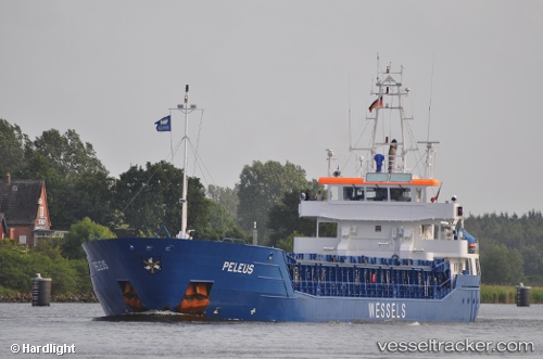
 Peleus
Current Status
Where is the vessel?
Peleus is currently in Near Altenwerder, based on AIS data received less than 1h ago.
Latest AIS update:
Current position: 53.51976° N, 9.89102° E (Near Altenwerder)
Average speed (last 7 days): Loading…
Average speed (last 30 days): Loading…
Vessel profile: Peleus is a Multi Purpose Carrier with dimensions 88m x 13m.
This page combines live AIS, route history, probable destination signals, nearby traffic, and port activity for practical vessel monitoring.
The current position of vessel Peleus is 53.51976 lat / 9.89102 lng. Updated: 2026-04-08 13:58:32 UTCNearest reference points:
- Near Bahrenfeld
- Near Hamburg-Mitte
- Near Allermöhe
Currently sailing under the flag of Antigua Barbuda ![]()
Peleus built in 2009 year
Deadweight:
3660 tDetails:
Live Vessel Peleus Analytics (details, animations, etc.)
Recent AIS points (UTC):
2026-04-08 08:01:32 UTC · 53.51957, 9.89118 · SOG 0 kn · COG 231°2026-04-08 09:55:33 UTC · 53.51958, 9.89118 · SOG 0 kn · COG 231°
2026-04-08 11:58:33 UTC · 53.51958, 9.89118 · SOG 0 kn · COG 231°
2026-04-08 13:58:32 UTC · 53.51976, 9.89102 · SOG 0.6 kn · COG 222°