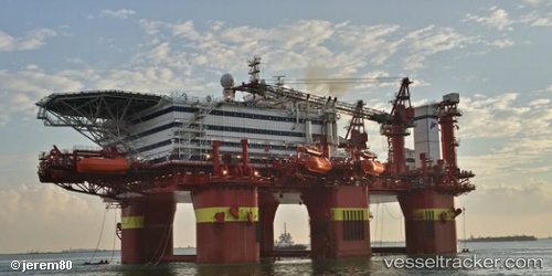
Floatel Victory
Current StatusWhere is the vessel?
Floatel Victory is currently in 60 nm W of Cidade de Angra dos Reis FPSO, based on AIS data received about 22h ago.
Latest AIS update:
Current position: 25.47503° S, 43.93708° W (60 nm W of Cidade de Angra dos Reis FPSO)
Average speed (last 7 days): Loading…
Average speed (last 30 days): Loading…
Vessel profile: Floatel Victory is a Offshore Vessel with dimensions 30m x 119m.
This page combines live AIS, route history, probable destination signals, nearby traffic, and port activity for practical vessel monitoring.
The current position of vessel Floatel Victory is -25.47503 lat / -43.93708 lng. Updated: 2026-07-02 13:09:27 UTCNearest reference points:
- 61 nm S of TEBIG
- 34 nm S of Cidade de Angra dos Reis FPSO
- 49 nm S of SEPETIBA
Details:
Live Vessel Floatel Victory Analytics (details, animations, etc.)
Recent AIS points (UTC):
2026-07-02 13:09:27 UTC · -25.47503, -43.93708 · SOG 0.1 kn · COG -1°2026-07-02 13:09:27 UTC · -25.47503, -43.93708 · SOG 0.1 kn · COG -1°
2026-07-02 13:09:27 UTC · -25.47503, -43.93708 · SOG 0.1 kn · COG -1°
2026-07-02 13:09:27 UTC · -25.47503, -43.93708 · SOG 0.1 kn · COG -1°