 vesseltracker.com
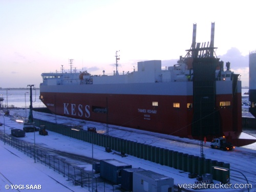
 Thames Highway
Current Status
Where is the vessel?
Thames Highway is currently in Near TYNE, based on AIS data received about 1h ago.
Latest AIS update:
Current position: 54.99103° N, 1.45116° W (Near TYNE)
Average speed (last 7 days): Loading…
Average speed (last 30 days): Loading…
Vessel profile: Thames Highway is a Vehicles Carrier with dimensions 148m x 25m.
This page combines live AIS, route history, probable destination signals, nearby traffic, and port activity for practical vessel monitoring.
The current position of vessel Thames Highway is 54.99103 lat / -1.45116 lng. Updated: 2026-04-26 02:31:38 UTCNearest reference points:
- Near TYNE
- Near Blyth
- Near North Berwick
Currently sailing under the flag of Bahamas ![]()
Thames Highway built in 2005 year
Deadweight:
7750 tDetails:
Live Vessel Thames Highway Analytics (details, animations, etc.)
Recent AIS points (UTC):
2026-04-25 22:05:11 UTC · 54.99167, -1.45167 · SOG 0 kn · COG -1°2026-04-26 00:10:37 UTC · 54.99101, -1.45117 · SOG 0 kn · COG 214°
2026-04-26 01:37:36 UTC · 54.99102, -1.45116 · SOG 0 kn · COG 214°
2026-04-26 02:31:38 UTC · 54.99103, -1.45116 · SOG 0 kn · COG 214°