 Chesapeake Highway
Current Status
Where is the vessel?
Chesapeake Highway is currently in Near PORTBURY, based on AIS data received about 14h ago.
Latest AIS update:
Current position: 51.49470° N, 2.71439° W (Near PORTBURY)
Average speed (last 7 days): Loading…
Average speed (last 30 days): Loading…
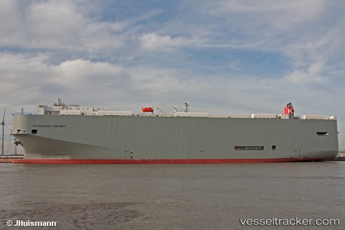
Vessel profile: Chesapeake Highway is a Vehicles Carrier with dimensions 200m x 32m.
This page combines live AIS, route history, probable destination signals, nearby traffic, and port activity for practical vessel monitoring.
The current position of vessel Chesapeake Highway is 51.49470 lat / -2.71439 lng. Updated: 2026-05-20 01:56:03 UTCNearest reference points:
- Near PORTBURY
- Near Avonmouth
- Near Bird Port
Currently sailing under the flag of Panama ![]()
Chesapeake Highway built in 2010 year
Deadweight:
21643 tDetails:
Live Vessel Chesapeake Highway Analytics (details, animations, etc.)
Recent AIS points (UTC):
2026-05-19 23:06:06 UTC · 51.49473, -2.71437 · SOG 0 kn · COG 48°2026-05-20 00:09:21 UTC · 51.49470, -2.71441 · SOG 0 kn · COG 48°
2026-05-20 01:15:06 UTC · 51.49469, -2.71439 · SOG 0 kn · COG 48°
2026-05-20 01:56:03 UTC · 51.49470, -2.71439 · SOG 0 kn · COG 48°