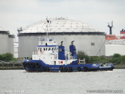
 East Coast
Current Status
Where is the vessel?
East Coast is currently in Near Baltimore, based on AIS data received about 14h ago.
Latest AIS update:
Current position: 39.26459° N, 76.57189° W (Near Baltimore)
Average speed (last 7 days): Loading…
Average speed (last 30 days): Loading…
Vessel profile: East Coast is a Tug with dimensions 34m x 34m.
This page combines live AIS, route history, probable destination signals, nearby traffic, and port activity for practical vessel monitoring.
The current position of vessel East Coast is 39.26459 lat / -76.57189 lng. Updated: 2026-05-21 19:33:04 UTCNearest reference points:
- Near Baltimore
- Near South Baltimore
- Near DUNDALK
Currently sailing under the flag of USA ![]()
Details:
Live Vessel East Coast Analytics (details, animations, etc.)
Recent AIS points (UTC):
2026-05-21 16:20:05 UTC · 39.25659, -76.56975 · SOG 8.8 kn · COG 329°2026-05-21 18:13:15 UTC · 39.26458, -76.57191 · SOG 0 kn · COG 90°
2026-05-21 19:22:54 UTC · 39.26460, -76.57189 · SOG 0 kn · COG 88°
2026-05-21 19:33:04 UTC · 39.26459, -76.57189 · SOG 0 kn · COG 89°