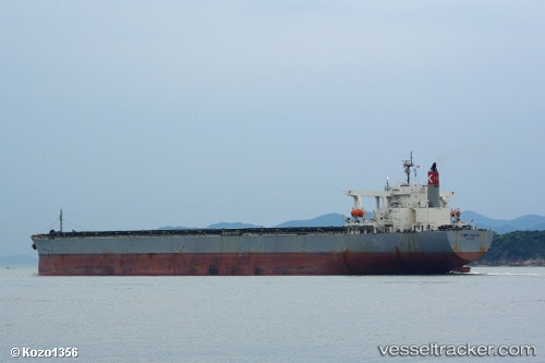
.
Vessel photo of Cape Maple (IMO 9281918) vesseltracker.com

Cape Maple

Vessel type: Ore Carrier | IMO: 9281918 | MMSI: MMSI: 371351000
Call sign: 3ECF4 | Dimensions: 50 m x 300 m
Current Status

Where is the vessel?

Cape Maple is currently in 69 nm SW of Jeddah, based on AIS data received about 1115d ago.

Latest AIS update:

Current position: 20.94548° N, 38.04722° E (69 nm SW of Jeddah)

Average speed (last 7 days): Loading…

Average speed (last 30 days): Loading…

Vessel profile: Cape Maple is a Ore Carrier with dimensions 50m x 300m.

This page combines live AIS, route history, probable destination signals, nearby traffic, and port activity for practical vessel monitoring.

The current position of vessel Cape Maple is 20.94548 lat / 38.04722 lng. Updated: 2023-03-13 16:25:30 UTC
Nearest reference points:
  • 64 nm W of Tusdeer Free Zone
  • 67 nm W of Tusdeer Free Zone
  • 65 nm SW of King Abdullah City
Details:

Live Vessel Cape Maple Analytics (details, animations, etc.)


Recent AIS points (UTC):
2023-03-13 16:25:30 UTC · 20.94548, 38.04722 · SOG 13.2 kn · COG 334°

Track of the vessel in the last 60 days


UTC: --
Start: -- Track timeline (UTC) End: --
Encountered: --


Link to the map:


Find another ship

Cape_Maple (371351000) last ports (portcalls and passsages)

Dagu Bar | 2023-02-04 02:15:09
Taku Bar | 2023-02-02 23:29:05
Lianyungang | 2023-01-30 02:43:06
Port Headland | 2023-01-12 15:00:50
Port Headland | 2022-11-20 05:25:33
Esperance | 2022-10-02 01:23:42
Esperance | 2022-09-27 22:51:10
Esperance | 2022-09-23 22:17:11
Singapore | 2022-05-20 19:26:01
Sambu | 2022-05-20 19:15:17
Taku Bar | 2022-05-07 01:23:22
Port Headland | 2022-04-20 12:30:33
Selat Lombok | 2022-04-11 12:11:16
Wusong | 2022-03-30 06:02:51
Singapore | 2021-12-30 19:45:38
Sambu | 2021-12-30 19:30:16
Lianyungang | 2021-12-13 04:48:32