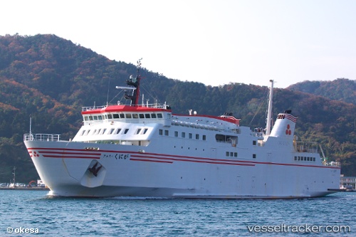
Ferry Kuniga
Current StatusWhere is the vessel?
Ferry Kuniga is currently in Near NAKANOSHIMA, based on AIS data received about 14h ago.
Latest AIS update:
Current position: 35.95601° N, 133.11617° E (Near NAKANOSHIMA)
Average speed (last 7 days): Loading…
Average speed (last 30 days): Loading…
Vessel profile: Ferry Kuniga is a Passenger Ro Ro Cargo Ship with dimensions 16m x 103m.
This page combines live AIS, route history, probable destination signals, nearby traffic, and port activity for practical vessel monitoring.
The current position of vessel Ferry Kuniga is 35.95601 lat / 133.11617 lng. Updated: 2026-06-30 02:23:13 UTCNearest reference points:
- 37 nm NW of NAKANOSHIMA
- 15 nm NW of SHIMONOHAMA
- 63 nm NW of Unnan
Details:
Live Vessel Ferry Kuniga Analytics (details, animations, etc.)
Recent AIS points (UTC):
2026-06-29 09:30:25 UTC · 36.20332, 133.33582 · SOG 0.5 kn · COG 15°2026-06-29 23:12:44 UTC · 36.20328, 133.33577 · SOG 0.1 kn · COG 20°
2026-06-30 01:09:34 UTC · 36.10805, 133.04146 · SOG 0 kn · COG 279°
2026-06-30 02:23:13 UTC · 35.95601, 133.11617 · SOG 18.8 kn · COG 155°