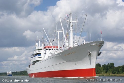
.
Vessel photo of Cap San Diego (IMO 5060794) vesseltracker.com

DE flag Cap San Diego

Vessel type: Multi Purpose Carrier | IMO: 5060794 | MMSI: MMSI: 211855000
Call sign: DNAI | Dimensions: 160 m x 20 m
Current Status

Where is the vessel?

Cap San Diego is currently in Near Hamburg-Mitte, based on AIS data received about 14h ago.

Latest AIS update:

Current position: 53.54321° N, 9.97617° E (Near Hamburg-Mitte)

Average speed (last 7 days): Loading…

Average speed (last 30 days): Loading…

Vessel profile: Cap San Diego is a Multi Purpose Carrier with dimensions 160m x 20m.

This page combines live AIS, route history, probable destination signals, nearby traffic, and port activity for practical vessel monitoring.

The current position of vessel Cap San Diego is 53.54321 lat / 9.97617 lng. Updated: 2026-05-17 23:23:37 UTC
More recent position available: 8 min ago

Shipinfo shows free vessel positions with a delay. After payment, you will be able to view the current position of this vessel for 24 hours.

We recommend registering. If you register, paid vessel access will be saved in your profile. Guest access works only through a personal link.

Nearest reference points:
  • Near Hamburg-Mitte
  • Near Bahrenfeld
  • Near Allermöhe

Currently sailing under the flag of Germany DE flag

Cap San Diego built in 1962 year

Deadweight:
10017 t

Details:

Live Vessel Cap San Diego Analytics (details, animations, etc.)


Recent AIS points (UTC):
2026-05-17 20:08:37 UTC · 53.54321, 9.97621 · SOG 0 kn · COG 298°
2026-05-17 21:41:33 UTC · 53.54320, 9.97620 · SOG 0 kn · COG 299°
2026-05-17 22:41:33 UTC · 53.54322, 9.97621 · SOG 0 kn · COG 298°
2026-05-17 23:23:37 UTC · 53.54321, 9.97617 · SOG 0 kn · COG 299°

Track of the vessel in the last 60 days


UTC: --
Start: -- Track timeline (UTC) End: --
Encountered: --


Link to the map:


Find another ship

Cap_San_Diego (211855000) last ports (portcalls and passsages)

Wilhelmsburg | 2025-09-15 12:41:43
Wilhelmsburg | 2025-09-08 11:14:43
Wilhelmsburg | 2025-09-02 14:43:01
WEDEL | 2025-08-19 13:43:59
STADE | 2025-08-19 13:19:09
FREIBURG | 2025-08-19 11:57:11
Brake | 2025-08-17 16:12:37
Nordenham | 2025-08-16 01:46:41
Cuxhaven | 2025-08-15 14:13:56
BRUNSBUETTEL | 2025-08-15 11:40:21
FREIBURG | 2025-08-15 10:37:04
STADE | 2025-08-15 09:47:19
FREIBURG | 2025-07-20 15:36:41
Cuxhaven | 2025-07-19 14:58:37
BRUNSBUETTEL | 2025-07-19 11:53:05
GLUECKSTADT | 2025-07-19 10:30:33
STADE | 2025-07-19 09:39:04
WEDEL | 2025-07-19 09:24:30
STADE | 2025-06-21 17:33:38
Stadersand | 2025-06-21 16:35:19
WEDEL | 2025-06-21 16:24:27
STADE | 2025-05-10 09:59:35
Stadersand | 2024-09-14 10:55:49
Cuxhaven | 2024-08-24 13:32:09
Stadersand | 2024-08-24 09:53:29
Stadersand | 2024-07-21 12:56:53
Cuxhaven | 2024-07-20 17:25:44
Stadersand | 2024-06-29 12:13:15
Stadersand | 2024-05-09 10:45:14
Nord-Ostsee-Kanal | 2023-09-17 18:24:08
Stadersand | 2023-09-15 10:25:44
Stadersand | 2023-09-02 13:57:22
Stadersand | 2023-07-16 12:22:27
Cuxhaven | 2023-07-15 14:28:43
Stadersand | 2023-06-17 17:36:56
Stadersand | 2023-05-05 09:25:54
Nord-Ostsee-Kanal | 2022-08-10 13:56:09
Nord-Ostsee-Kanal | 2022-08-06 13:11:43
Stadersand | 2022-08-05 10:12:56
Stadersand | 2022-07-26 13:40:01
Cuxhaven | 2022-07-25 19:54:08
Bremerhaven | 2022-07-25 14:04:40
Cuxhaven | 2022-07-21 13:27:14
Stadersand | 2022-05-06 10:29:45