 vesseltracker.com
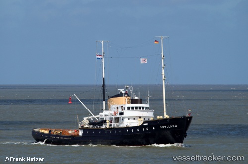
Vessel Holland IMO: 5153462, MMSI: 244879000 Tug
UTC, 53.17043, 5.41305, course: 326, speed: 0
UTC, 53.17045, 5.41304, course: 326, speed: 0
2026-03-24 20:08:33 UTC, 53.17043, 5.41306, course: 326, speed: 0
Live Vessel Holland Analytics (details, animations, etc.)
Live AIS position: UTC. Near HARLINGEN), updated 2026-03-24 20:08:33 UTC.Find the position of the vessel Holland on the map. The latter are known coordinates and path.
marine traffic ship tracker show on live map
The current position of vessel Holland is 53.17043 lat / 5.41306 lng. Updated: 2026-03-24 20:08:33 UTCCurrently sailing under the flag of Netherlands
Holland built in 1952 year
Details:
Last coordinates of the vessel:
UTC, 53.17045, 5.41304, course: 326, speed: 0UTC, 53.17043, 5.41305, course: 326, speed: 0
UTC, 53.17045, 5.41304, course: 326, speed: 0
2026-03-24 20:08:33 UTC, 53.17043, 5.41306, course: 326, speed: 0