 vesseltracker.com
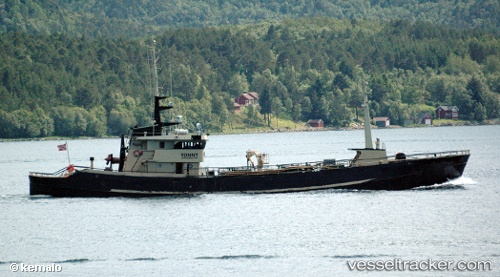
 Tonny
Tonny
Current Status
Where is the vessel?
Tonny is currently in Near Harstad, based on AIS data received about 15h ago.
Latest AIS update:
Current position: 68.78857° N, 16.54263° E (Near Harstad)
Average speed (last 7 days): Loading…
Average speed (last 30 days): Loading…
Vessel profile: Tonny is a Water Tanker with dimensions 48m x 8m.
This page combines live AIS, route history, probable destination signals, nearby traffic, and port activity for practical vessel monitoring.
The current position of vessel Tonny is 68.78857 lat / 16.54263 lng. Updated: 2026-05-17 23:22:55 UTCNearest reference points:
- Near Harstad
- Near Skrolsvik
- Near Sigerfjord
Currently sailing under the flag of Norway ![]()
Tonny built in 1942 year
Details:
Live Vessel Tonny Analytics (details, animations, etc.)
Recent AIS points (UTC):
2026-05-17 20:08:39 UTC · 68.78860, 16.54259 · SOG 0 kn · COG -1°2026-05-17 21:43:50 UTC · 68.78859, 16.54262 · SOG 0 kn · COG -1°
2026-05-17 22:44:24 UTC · 68.78856, 16.54259 · SOG 0 kn · COG -1°
2026-05-17 23:22:55 UTC · 68.78857, 16.54263 · SOG 0 kn · COG -1°