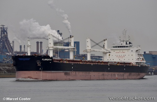
 FLORENTIA
Current Status
Where is the vessel?
FLORENTIA is currently in Open sea, approx. 485 nm off the nearest listed port, based on AIS data received about 14h ago.
Latest AIS update:
Current position: 16.29612° S, 28.95995° W (Open sea, approx. 485 nm off the nearest listed port)
Average speed (last 7 days): Loading…
Average speed (last 30 days): Loading…
Vessel profile: FLORENTIA is a Bulk Carrier with dimensions 32m x 200m.
This page combines live AIS, route history, probable destination signals, nearby traffic, and port activity for practical vessel monitoring.
The current position of vessel FLORENTIA is -16.29612 lat / -28.95995 lng. Updated: 2026-07-01 04:01:58 UTCNearest reference points:
- Open sea, approx. 485 nm off the nearest listed port
- Open sea, approx. 487 nm off the nearest listed port
- Open sea, approx. 488 nm off the nearest listed port
Currently sailing under the flag of Marshall Islands ![]()
FLORENTIA built in 2016 year
Deadweight:
63340 tDetails:
Live Vessel FLORENTIA Analytics (details, animations, etc.)
Recent AIS points (UTC):
2026-07-01 01:29:28 UTC · -16.02724, -28.55635 · SOG 11.2 kn · COG 233°2026-07-01 02:32:46 UTC · -16.13833, -28.72333 · SOG 11 kn · COG -1°
2026-07-01 03:52:29 UTC · -16.27919, -28.93506 · SOG 11 kn · COG 233°
2026-07-01 04:01:58 UTC · -16.29612, -28.95995 · SOG 11 kn · COG 233°