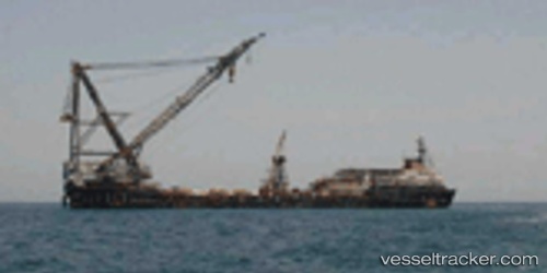
Hls 2000
Current StatusWhere is the vessel?
Hls 2000 is currently in Near Jumayrah, based on AIS data received about 14h ago.
Latest AIS update:
Current position: 25.20451° N, 55.17133° E (Near Jumayrah)
Average speed (last 7 days): Loading…
Average speed (last 30 days): Loading…
Vessel profile: Hls 2000 is a Crane Ship with dimensions 30m x 183m.
This page combines live AIS, route history, probable destination signals, nearby traffic, and port activity for practical vessel monitoring.
The current position of vessel Hls 2000 is 25.20451 lat / 55.17133 lng. Updated: 2026-07-05 04:40:31 UTCNearest reference points:
- Near Jumayrah
- Near Al Sufouh
- Near DUBAI MARINA
Details:
Live Vessel Hls 2000 Analytics (details, animations, etc.)
Recent AIS points (UTC):
2026-07-05 01:33:49 UTC · 25.20450, 55.17127 · SOG 0 kn · COG -1°2026-07-05 01:51:49 UTC · 25.20450, 55.17126 · SOG 0 kn · COG -1°
2026-07-05 03:55:50 UTC · 25.20449, 55.17124 · SOG 0 kn · COG -1°
2026-07-05 04:40:31 UTC · 25.20451, 55.17133 · SOG 0 kn · COG -1°