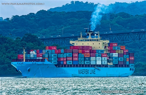
Maersk Innoshima
Current StatusWhere is the vessel?
Maersk Innoshima is currently in Near Mairangi Bay, based on AIS data received about 14h ago.
Latest AIS update:
Current position: 36.70367° S, 174.85445° E (Near Mairangi Bay)
Average speed (last 7 days): Loading…
Average speed (last 30 days): Loading…
Vessel profile: Maersk Innoshima is a Container Ship with dimensions 32m x 233m.
This page combines live AIS, route history, probable destination signals, nearby traffic, and port activity for practical vessel monitoring.
The current position of vessel Maersk Innoshima is -36.70367 lat / 174.85445 lng. Updated: 2026-05-27 16:15:06 UTCNearest reference points:
- Near Matiatia Bay
- Near GULF HARBOUR
- Near ORAKEI
Details:
Live Vessel Maersk Innoshima Analytics (details, animations, etc.)
Recent AIS points (UTC):
2026-05-27 13:36:01 UTC · -36.70497, 174.85141 · SOG 0 kn · COG 33°2026-05-27 13:51:02 UTC · -36.70520, 174.85170 · SOG 0.1 kn · COG 19°
2026-05-27 15:36:03 UTC · -36.70456, 174.85434 · SOG 0 kn · COG 298°
2026-05-27 16:15:06 UTC · -36.70367, 174.85445 · SOG 0 kn · COG 263°