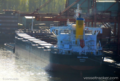
Medi Egadi
Current StatusWhere is the vessel?
Medi Egadi is currently in 39 nm S of Kosai-Shi, based on AIS data received about 14h ago.
Latest AIS update:
Current position: 34.07344° N, 137.61710° E (39 nm S of Kosai-Shi)
Average speed (last 7 days): Loading…
Average speed (last 30 days): Loading…
Vessel profile: Medi Egadi is a Bulk Carrier with dimensions 32m x 229m.
This page combines live AIS, route history, probable destination signals, nearby traffic, and port activity for practical vessel monitoring.
The current position of vessel Medi Egadi is 34.07344 lat / 137.61710 lng. Updated: 2026-06-23 07:48:26 UTCNearest reference points:
- 17 nm S of TOYOHASHI
- 17 nm SW of OMAEZAKI
- 12 nm E of TOBA
Details:
Live Vessel Medi Egadi Analytics (details, animations, etc.)
Recent AIS points (UTC):
2026-06-23 03:49:11 UTC · 33.83500, 137.09666 · SOG 0 kn · COG -1°2026-06-23 04:28:09 UTC · 33.82833, 137.08501 · SOG 5 kn · COG -1°
2026-06-23 05:37:12 UTC · 33.98333, 137.24167 · SOG 11 kn · COG -1°
2026-06-23 07:48:26 UTC · 34.07344, 137.61710 · SOG 2.6 kn · COG 66°