 vesseltracker.com
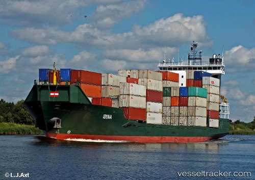
 SKYLIGHT
Current Status
Where is the vessel?
SKYLIGHT is currently in Near GELENDZHIK, based on AIS data received about 2h ago.
Latest AIS update:
Current position: 44.61877° N, 37.96194° E (Near GELENDZHIK)
Average speed (last 7 days): Loading…
Average speed (last 30 days): Loading…
Vessel profile: SKYLIGHT is a Container Ship with dimensions 126m x 22m.
This page combines live AIS, route history, probable destination signals, nearby traffic, and port activity for practical vessel monitoring.
The current position of vessel SKYLIGHT is 44.61877 lat / 37.96194 lng. Updated: 2026-05-16 01:03:20 UTCNearest reference points:
- Near GELENDZHIK
- Near Novorossiysk
- 11 nm SE of GELENDZHIK
Currently sailing under the flag of Liberia ![]()
SKYLIGHT built in 2007 year
Deadweight:
8820 tDetails:
Live Vessel SKYLIGHT Analytics (details, animations, etc.)
Recent AIS points (UTC):
2026-05-15 23:43:53 UTC · 44.62584, 37.80215 · SOG 7.9 kn · COG 223°2026-05-16 01:03:20 UTC · 44.61877, 37.96194 · SOG 7.8 kn · COG 220°
2026-05-16 01:03:20 UTC · 44.61877, 37.96194 · SOG 7.8 kn · COG 220°
2026-05-16 01:03:20 UTC · 44.61877, 37.96194 · SOG 7.8 kn · COG 220°