 vesseltracker.com
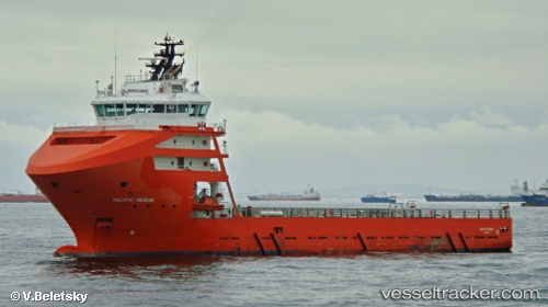
 PACIFIC HERON
Current Status
Where is the vessel?
PACIFIC HERON is currently in 180 nm W of Koiingnaas, based on AIS data received about 1h ago.
Latest AIS update:
Current position: 29.55660° S, 13.90903° E (180 nm W of Koiingnaas)
Average speed (last 7 days): Loading…
Average speed (last 30 days): Loading…
Vessel profile: PACIFIC HERON is a Offshore Supply Ship with dimensions m x m.
This page combines live AIS, route history, probable destination signals, nearby traffic, and port activity for practical vessel monitoring.
The current position of vessel PACIFIC HERON is -29.55660 lat / 13.90903 lng. Updated: 2026-04-27 23:38:01 UTCNearest reference points:
- 161 nm W of Koiingnaas
- 154 nm W of Koiingnaas
- 167 nm SW of Koiingnaas
Currently sailing under the flag of Liberia ![]()
Details:
Live Vessel PACIFIC HERON Analytics (details, animations, etc.)
Recent AIS points (UTC):
2026-04-27 20:15:38 UTC · -29.55623, 13.91076 · SOG 0.2 kn · COG 167°2026-04-27 22:04:09 UTC · -29.55644, 13.90995 · SOG 1.9 kn · COG 166°
2026-04-27 22:50:10 UTC · -29.55662, 13.90908 · SOG 0.3 kn · COG 163°
2026-04-27 23:38:01 UTC · -29.55660, 13.90903 · SOG 1.3 kn · COG 163°