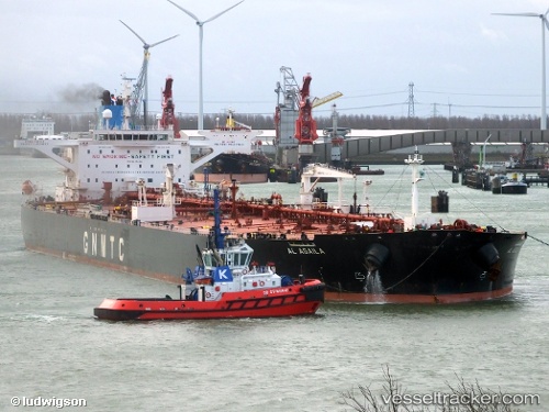
 Al Agaila
Current Status
Where is the vessel?
Al Agaila is currently in Near SANTA PANAGIA, based on AIS data received about 14h ago.
Latest AIS update:
Current position: 37.11596° N, 15.26708° E (Near SANTA PANAGIA)
Average speed (last 7 days): Loading…
Average speed (last 30 days): Loading…
Vessel profile: Al Agaila is a Crude Oil Tanker with dimensions 274m x 274m.
This page combines live AIS, route history, probable destination signals, nearby traffic, and port activity for practical vessel monitoring.
The current position of vessel Al Agaila is 37.11596 lat / 15.26708 lng. Updated: 2026-06-24 15:21:35 UTCNearest reference points:
- Near SANTA PANAGIA
- Near Pier Isab
- Near Siracusa
Currently sailing under the flag of Libya ![]()
Details:
Live Vessel Al Agaila Analytics (details, animations, etc.)
Recent AIS points (UTC):
2026-06-24 12:21:37 UTC · 37.11593, 15.26713 · SOG 0 kn · COG 48°2026-06-24 13:45:30 UTC · 37.11593, 15.26710 · SOG 0 kn · COG 48°
2026-06-24 13:48:36 UTC · 37.11595, 15.26714 · SOG 0 kn · COG 48°
2026-06-24 15:21:35 UTC · 37.11596, 15.26708 · SOG 0 kn · COG 48°