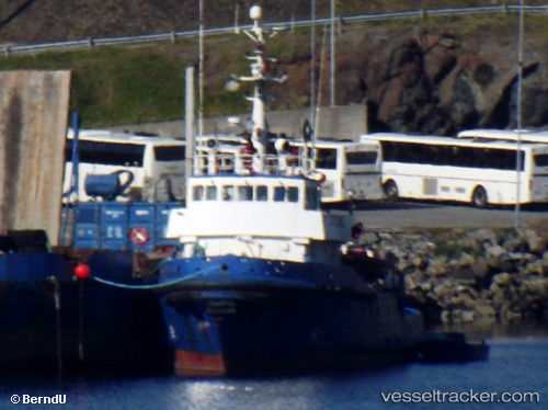
vessel Stone IMO: 6917516, Tug
vesseltracker.com
Vessel Stone IMO: 6917516, Tug
MMSI: 259531000 callsign: LAUT size: 37x10
Live AIS position: 56.70022° N, 8.21593° E UTC. Near Thyborøn), updated 2023-10-16 07:44:54 UTC.

Find the position of the vessel Stone on the map. The latter are known coordinates and path.

marine traffic ship tracker show on live map

The current position of vessel Stone is 56.70022 lat / 8.21593 lng. Updated: 2023-10-16 07:44:54 UTC

Currently sailing under the flag of Norway

Stone built in 1969 year

Details:


Last coordinates of the vessel:
2023-10-16 07:44:54 UTC, 56.70022, 8.21593, course: 352, speed: 0

Track of the vessel in the last 14 days


Most frequent ports a vessels calls at Stone (259531000):

Kristiansund, traffic: 10
Namsos, traffic: 8
Tromso, traffic: 7
Alesund, traffic: 6
Bodo, traffic: 5
Harstad, traffic: 5
Mo I Rana, traffic: 4
Hammerfest, traffic: 2
Molde, traffic: 2
Mosjoen, traffic: 1

Link to the map:


Find another ship

Stone (259531000) last ports (portcalls and passsages)

Mo I Rana | 2022-06-26 16:40:52
Mosjoen | 2022-06-23 01:02:17
Namsos | 2022-06-08 04:38:13
Bodo | 2022-06-06 10:24:57
Harstad | 2022-06-05 05:04:43
Tromso | 2022-06-04 07:52:39
Tromso | 2022-05-28 07:17:19
Hammerfest | 2022-05-24 19:14:09
Tromso | 2022-05-23 17:02:03
Harstad | 2022-05-22 22:28:39
Tromso | 2022-05-18 07:43:01
Hammerfest | 2022-05-14 19:40:15
Tromso | 2022-05-13 22:55:45
Harstad | 2022-05-13 08:10:15
Namsos | 2022-05-02 12:52:36
Mo I Rana | 2022-04-23 15:40:32
Tromso | 2022-04-17 15:00:54
Harstad | 2022-04-17 00:25:44
Bodo | 2022-04-16 06:35:48
Namsos | 2022-04-13 00:30:29
Kristiansund | 2022-04-12 04:15:06
Molde | 2022-04-09 12:35:36
Alesund | 2022-04-09 06:35:58
Kristiansund | 2022-04-03 07:00:28
Namsos | 2022-03-30 03:24:23
Kristiansund | 2022-03-18 15:05:56
Alesund | 2022-03-09 09:10:12
Kristiansund | 2022-03-08 15:25:11
Namsos | 2022-03-03 12:47:34
Kristiansund | 2022-02-26 12:30:48
Alesund | 2022-02-22 03:05:10
Mo I Rana | 2022-02-18 19:10:59
Bodo | 2022-02-16 10:15:14