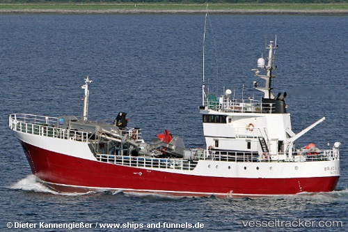
Brudanes
Current StatusWhere is the vessel?
Brudanes is currently in 25 nm SE of Melinka, based on AIS data received about 14h ago.
Latest AIS update:
Current position: 44.21536° S, 73.43529° W (25 nm SE of Melinka)
Average speed (last 7 days): Loading…
Average speed (last 30 days): Loading…
Vessel profile: Brudanes is a Fish Carrier with dimensions 8m x 49m.
This page combines live AIS, route history, probable destination signals, nearby traffic, and port activity for practical vessel monitoring.
The current position of vessel Brudanes is -44.21536 lat / -73.43529 lng. Updated: 2026-07-08 12:38:53 UTCNearest reference points:
- Near Melinka
- Near Quellón (Puerto Quellón)
- Near Chonchi
Details:
Live Vessel Brudanes Analytics (details, animations, etc.)
Recent AIS points (UTC):
2026-07-08 09:23:59 UTC · -43.81212, -73.38955 · SOG 7.4 kn · COG 177°2026-07-08 09:51:40 UTC · -43.87114, -73.39226 · SOG 7.8 kn · COG 176°
2026-07-08 11:40:00 UTC · -44.09667, -73.40500 · SOG 7 kn · COG -1°
2026-07-08 12:38:53 UTC · -44.21536, -73.43529 · SOG 7.5 kn · COG 175°