 Norma H Ii
Current Status
Where is the vessel?
Norma H Ii is currently in Near CAP HAITIEN, based on AIS data received about 579d ago.
Latest AIS update:
Current position: 19.75842° N, 72.19659° W (Near CAP HAITIEN)
Average speed (last 7 days): Loading…
Average speed (last 30 days): Loading…
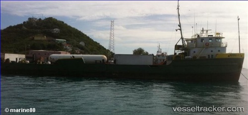
Vessel profile: Norma H Ii is a Offshore Tug Supply Ship with dimensions 51m x 12m.
This page combines live AIS, route history, probable destination signals, nearby traffic, and port activity for practical vessel monitoring.
The current position of vessel Norma H Ii is 19.75842 lat / -72.19659 lng. Updated: 2024-11-14 15:53:41 UTCNearest reference points:
- 56 nm SW of Cockburn Harbour
- 47 nm SW of Cockburn Harbour
- 38 nm SW of Cockburn Harbour
Currently sailing under the flag of Togo ![]()
Norma H Ii built in 1972 year
Details:
Live Vessel Norma H Ii Analytics (details, animations, etc.)
Recent AIS points (UTC):
2024-11-14 15:53:41 UTC · 19.75842, -72.19659 · SOG 0.1 kn · COG -1°