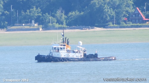
Atlantic Teak
Current StatusWhere is the vessel?
Atlantic Teak is currently in Near PORT HARDY, based on AIS data received about 521d ago.
Latest AIS update:
Current position: 50.70943° N, 127.52134° W (Near PORT HARDY)
Average speed (last 7 days): Loading…
Average speed (last 30 days): Loading…
Vessel profile: Atlantic Teak is a Tug with dimensions 9m x 31m.
This page combines live AIS, route history, probable destination signals, nearby traffic, and port activity for practical vessel monitoring.
The current position of vessel Atlantic Teak is 50.70943 lat / -127.52134 lng. Updated: 2024-12-15 18:27:24 UTCNearest reference points:
- Near PORT HARDY
- 29 nm NW of Coal Harbour
- 63 nm N of PORT HARDY
Details:
Live Vessel Atlantic Teak Analytics (details, animations, etc.)
Recent AIS points (UTC):
2024-12-15 18:27:24 UTC · 50.70943, -127.52134 · SOG 0 kn · COG 216°